As previously featured in the History Centre
January - March 2009
|
| Archive of Monthly News Items As previously featured in the History Centre January - March 2009 |
| January 2009
| |||||||
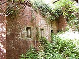
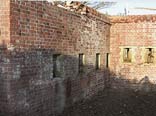
As the holiday facilities developed, parts of the fort were increasingly flattened with the remaining sections left to become heavily overgrown. The new owner acquired the site last summer and decided the remains should not only be preserved but recovered to form an integral part of a redesigned holiday centre. Much of the surrounding Carnot wall has long since gone but most of the long seaward section remains, together with its two musketry Caponiers. The ditch fronting this has now been completely excavated, bringing the section back to its original state. The fort's main gun emplacements still survive and these will be cleared to form a feature of the revised holiday facilities. A few other structures remain, including a pump house and the original winch room, complete with the winch that controlled a horizontal sliding drawbridge. It is planned to incorporate a small museum covering the history of the battery. The state of the Island's other Palmerston Forts range from near complete to virtually gone. The most vulnerable have been those under private ownership, where there is either a lack of resources for preservation or they stand in the way of development. The unprompted resurrection of Yaverland Battery is an unexpected reversal of its fortunes and shows how enlightened business can contribute to, and benefit from, conservation. | |||||||
| February 2009
| ||||
Thereafter it became an example of how quickly a mill can deteriorate once it stops operating, having run continuously for over 200 years. In recent times the external units had reached the point where they were beyond basic repair. The owner contracted an experienced mill engineer, Malcolm Cooper, to carry out a fundamental rebuild and repair project, as necessary to bring the mill back into flour production. A new overshot water wheel had to be built (above), with the design as near as possible to the original. The launder, which feeds water onto the wheel, had also rotted and was renewed. The internal mechanics were in reasonable condition but required a general overhaul. A major bearing was re-engineered and the pit wheel had to be reset. There are still a few minor repairs needed to finalise the project but the stones have been redressed and the mill has already produced a trial quantity of flour, from which a loaf was baked - perhaps the first loaf out of Yafford Mill for nearly a century. | ||||
| March 2009
| |||||||
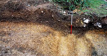
David Motkin first detected the boundary in the late 1970s during observations of 1948 Ordnance Survey aerial photos and also in subsequent analysis of 1946 RAF work, although many field boundaries showing in these photos had been levelled by the time it was discovered. It hasn't been physically checked along its entire length but some sections still show the bank and ditch profile. The excavation at Lynbottom consisted of trenches cut across the boundary. They revealed a section of the U shaped ditch with an intriguing double-gully at the base, rising to a bank on the east side. There were no finds but material was collected in the hope it can be dated by the OSL method. If the general period can be established, it will at least allow comparison with similar features elsewhere from the same period. Archaeologists will be keen to try and ascertain whether the double-gully served a practical purpose or simply represents local custom.
| |||||||